
Sardinia breathes at the weekend: temperatures dropping by at least 10 degrees
Also in the island the influences of a polar disturbance coming from Sweden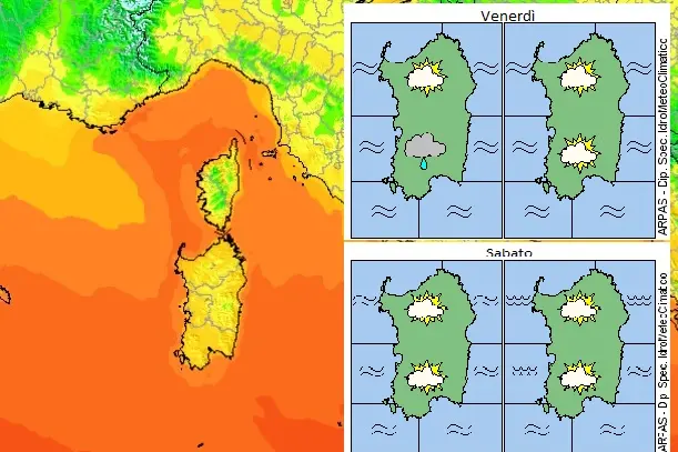
Per restare aggiornato entra nel nostro canale Whatsapp
First the effects of the now former hurricane Danielle, then in the night between Friday and Saturday a polar disturbance from Sweden: these are the climatic phenomena that between tomorrow, Friday 16 September, and Sunday, will put an end to a long period of heat and mugginess, even in Sardinia. Over the weekend on the island, the highs will drop by over 10 degrees: from 35-37 in the last few days to 20-25.
In the next 24 hours, Danielle's aftermath will still dictate the law in Italy, with heavy rains and thunderstorms, especially in the Triveneto and along the Tyrrhenian regions.
Immediately afterwards, on the night between Friday and Saturday, a cold disturbance from Sweden will arrive: in addition to the rains, it will also cause a drop in temperatures that is defined as "extreme and sudden".
On the Sardinian front, according to the Arpas hydrometeoclimatic department, the sky will be cloudy with isolated precipitations, also of a downpour or thunderstorm, with weak accumulations mainly in the southern areas. An attenuation of the phenomena is expected in the evening. There will also be the first drop in temperatures, with the entry of weak or moderate mistral currents from the northwest.
The coolness will become more consistent the following day, Saturday, with the mistral reinforcing especially on the most exposed coasts, where the gusts could reach 100 kilometers per hour.
(Unioneonline / EF)


