
New weather alert for Sardinia: heavy rain expected, followed by temperatures dropping 10 degrees.
Civil Protection advisory for the island for today and tomorrowVideo di Virginia Devoto
Weather warning in Sardinia, zones changing. Yesterday, the Civil Protection Department issued a warning primarily affecting western areas—with a yellow risk of thunderstorms—while today the same offices issued a bulletin that today concerns Sarrabus and Baronia, while tomorrow the critical situation will affect half of Sardinia: the hydrogeological risk affects Sulcis, the Cagliari area, and all eastern areas up to Gallura.
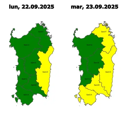
This is what the maps say. The accompanying text indicates danger from 2:00 PM today until 9:00 PM tomorrow for Iglesiente, Campidano, the Flumendosa and Flumineddu areas, Gallura, and Logudoro.

The deterioration is already underway. Meanwhile, starting Wednesday, temperatures will drop sharply, dropping as much as 10 degrees, as Lieutenant Colonel Carlo Spanu of the Italian Air Force meteorological service in Decimomannu explains: "Today's weather system will bring rain to the central-northern part of the island, which will then extend to the rest of Sardinia by the end of the day. Then, over the next few days, the arrival of mistral winds will bring a drastic drop in temperatures. Between Wednesday and Thursday, both minimum and maximum temperatures will drop as much as 10 degrees in less than 24 hours: inland, we will record lows of 6 degrees, and maximum temperatures will also drop, not exceeding 24 degrees in coastal areas."
(Unioneonline)


 from a disabled man, he stops her but falls from the wheelchair and pulls down her trousers")


