
Cyclone Pulcinella arrives: rainy weekend in Sardinia
More intense phenomena on Western sectors: worsening starting tomorrow. Strong winds also expected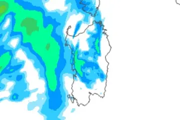
Per restare aggiornato entra nel nostro canale Whatsapp
With Carnival comes the cyclone Pulcinella, which will also bring rain back to Sardinia.
According to forecasts, over 100 millimeters could fall in northern Italy, while strong winds will blow across the entire territory and heavy snowfall is expected in the Alps. The sea will also become very rough or rough, with a gradual worsening starting in the next few hours and with peak between Friday afternoon and Sunday.
Tomorrow, 9 February, cyclone Pulcinella will still be far from Italy but will manage to activate very humid southern winds: rain is expected in the North-West and in Tuscany in the morning, also extending to the North-East during the day and towards Sardinia . The winds will blow up to a Scirocco gale. The peak of the bad weather, as mentioned, will arrive over the weekend with the cyclone deepening to 986 hPa on the Ligurian Sea and subsequently slowly moving towards the Central Adriatic: this very low pressure will unleash even stronger winds, particularly on Sicily and Sardinia .
According to the Arpas models, on the island tomorrow, Friday, cloudy skies are expected with light precipitation, including showers or thunderstorms, with weak cumulatives in the north-western sector starting in the evening. temperatures will rise. While on Saturday and Sunday the sky will be generally cloudy with precipitation which, in the western sector, may reach locally moderate cumulative amounts. Probable attenuation of the phenomena in the second part of the day on Sunday. Temperatures will tend to decrease.
(Unioneonline/E.Fr.)


