
«195 eaten by the sea, it's an emergency»: reef with 3-ton boulders against erosion
Anas presents an updated project to save the two-lane stretch between Cagliari and Capoterra from flooding: an investment of 8.5 million. Work also on the bridge "in terrible conditions"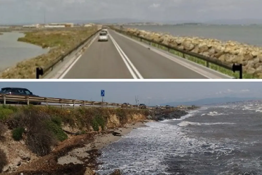
Per restare aggiornato entra nel nostro canale Whatsapp
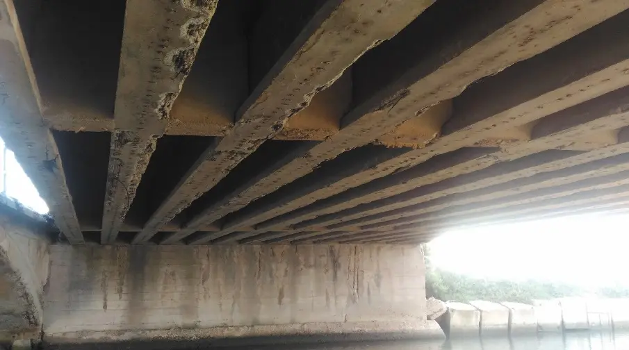
«Floods», especially in the winter, «occur more and more frequently» and have become «an emergency»: sometimes it is necessary to block traffic. The bridge «at kilometer 8+050 and the roadway next to it are in very poor condition: they require urgent extraordinary maintenance interventions». «Public safety» is in danger, so much so that «the intervention has been included in the Civil Protection Urgent Interventions Plan».
Thus Anas introduces the project to secure State Road 195, in the two-lane section "between progressives 5+500 and 8+700" squeezed between the sea, which is eating everything, and the Santa Gilla lagoon: an old artery no longer suited to the needs and monstrous volume of vehicles that pour into it every day. But the only alternative, at the moment: to secure against erosion through the construction of a reef.
A proposal that the road management company has just revised, filing new papers in the offices of the regional Department of the Environment, to find out whether the works should be subjected to an environmental impact assessment or not. A procedure that has been underway since 2019, which could be accelerated thanks to this new step: the Anas technicians have taken on board the indications that emerged during various service conferences and have formulated a new proposal.
The total cost of the works amounts to 8 million and 406 thousand euros: funds necessary to secure approximately 1.2 kilometers of road. Not a secondary artery: it connects the capital with the centers on the western side of the Golfo degli Angeli (Teulada, Domus de Maria, Pula, Villa San Pietro, Sarroch, Capoterra), with the passage of an average of 25 thousand vehicles per day (2,500 per hour between 8 and 9 in the morning, peak time).
The distance between the shoreline and the roadway is almost zero «in correspondence with the brush on the hydraulic left of the canal crossed by the “Ponti Becciu”» and « the evolutionary trend of the shoreline in the section of interest records a generalized retreat» . It will only get worse, therefore: some road collapses have already been recorded.
For this it will be necessary to build a reef over a length of 1200 meters (previously it was 2500). Newly supplied natural boulders weighing between one and three tons will be used, arranged in two rows, for the mantellata, and quarry stones weighing between 5 and 50 kilos for the base and the core . The project states that «the geometric characteristics of the defense work (footprint, height, etc.) were defined by combining the project objectives with the needs of environmental and landscape protection, that is, they are the result of a compromise between the need to defend the road infrastructure from marine ingress and erosion and the desire to minimize the naturalistic and landscape impact of the intervention».
It will also be necessary to intervene on the Ponti Becciu where, at present, «the lower strands of the beams are exposed and cut in several places and the abutments also have several points where the concrete cover has disappeared, exposing the reinforcement. Regarding the road embankment, the continuous action of the waves has eroded part of the embankment, reducing, in some places, even the embankment».
When the authorization arrives , Anas will try to minimize traffic inconvenience by building an alternative road.
Enrico Fresu


