
The mistral arrives, temperatures plummeting in Sardinia
Snowfalls above a thousand meters and possible storm surges are expected
Per restare aggiornato entra nel nostro canale Whatsapp
Rain, wind, frost and storms. The long weekend of the Immaculate Conception in Sardinia will be marked by bad weather that will accompany the island until next Sunday.
"On Sardinia the influx of north-western currents today guarantees temporary stability, however a new cloudy system arriving from France will cause a worsening of atmospheric conditions - explains first marshal Marco Formicola, of the Decimomannu Air Force Weather Office - . Cloudiness increasing in the evening today with precipitation in the early morning of tomorrow, Wednesday 8 December starting from the north-western sector and extending to the whole island with possible thunderstorms ".
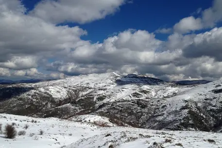
Already in the evening the phenomena will intensify with the possibility of snowfalls above a thousand meters.
"The mistral winds will rotate to libeccio on the 8th with a slight increase in temperatures in the morning - the expert emphasizes - with maximums between 16 and 20 degrees and minimums 12 and 16. From the afternoon the winds will rotate again to the mistral and will lead to a new lowering of temperatures ".
On Thursday 9th, the lows will generally be between 8 and 12 degrees, in the hinterland they will drop between 4 and 8 degrees, while the thermometer will go below zero in the central peaks of Sardinia. The mistral wind can reach up to 80 kilometers per hour until Saturday 11 December and then decrease in intensity on Sunday 12.
The seas will be rough or very rough, possible storm surges along the most exposed coasts.
(Unioneonline / vl)


 the Anti-Corruption Commission's decision.")


