
Landing of "war" in the Port of Cagliari
NATO radar aircraft flying over the internal areas of the island, Sardinia completely surrounded also on the air front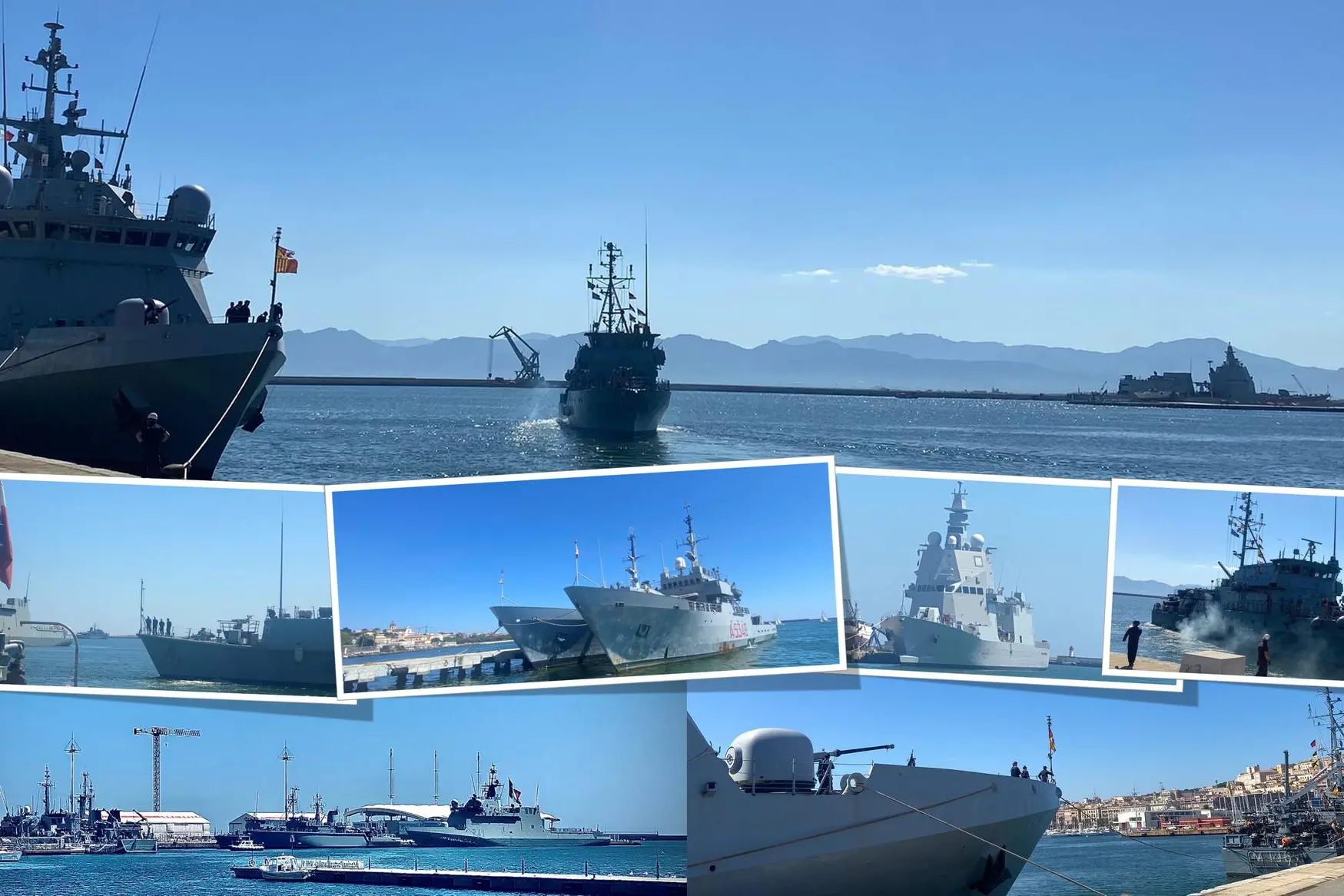
Per restare aggiornato entra nel nostro canale Whatsapp
The lighthouse on Molo Sabaudo is backlit when the super-rapid cannon in the prow of the “Meteoro”, the first patrol vessel of the Armada Española to cross the old port of Cagliari, stands out on the horizon. There is no breeze in the flat waters in front of Via Roma. The horizon is one of "war", wherever you see it. From the Levante pier to the Ponente one, the proscenium leaves no middle ground. Cagliari, the capital of the island, is under siege, in the true sense of the word. It is useless to count the warships deployed in a double row, from the Ichnusa quay to that of Rinascita.
Without notice
Military grandeur erupts without warning. Like that ordinance that the Palazzo del Mare in Piazza Deffenu, seat of the Port Authority of Cagliari, issued to order, "with immediate effect", the ban on "breathing" in the 17 areas indicated as if they were fenced with barbed wire in the middle of the Sardinian sea. Those satellite coordinates are more than just an invitation to stay away. In reality, however, in the map of the military occupation we reported yesterday, there was no Port of Cagliari. The show of strength, however, could not exempt itself from the "warmongering show" in the heart of the city. A warning message that does not reconcile with common sense and a sense of responsibility. To more than one observer, the result of making an entire island, Sardinia, the international center of gravity of an exercise as impressive as it is dangerous, appeared more than questionable. There is no doubt, in fact, that having concentrated international attention on the land most plundered and raped by military servants, with as many as 35 thousand hectares of territories occupied and fenced off for perennial war games, is already in itself a real danger. It is not only the announcement of a potential target, but it offers an even more disturbing reading of that "immediate effect" with which the military occupation of Sardinia was decided, including those areas outside the traditional shooting ranges. Imagining that prosceniums such as Poetto, Nora and Cala Pira, Porto Pino up to Muravera could be the subject of a military exercise allows us to understand the consideration of the island at the top. The German, Spanish, Italian, NATO and even the United States ships guard not only the Port of Cagliari but, since yesterday, are even preparing the "simulated mining" at sea of the roadstead in front of the Delta Peninsula of Capo Teulada. Internal sources tell of an operation that should already "target" the Charlie, Zafferano and Scudo area, in the extreme tip of Sardinia. The goal is the "demining" prepared by the Italian Navy and at the same time targeting the forbidden peninsula, the same that brought General and Chiefs of Staff of the Army and Defense to the dock on charges of environmental disaster . And it will certainly not be a coincidence this military exhibition in grand style, certainly planned, but not with this deployment of forces and above all with this unprecedented "intrusiveness" in Sardinia. The scenario at sea, however, is also accompanied by that in the sky, no less invasive and if we want even more alarming. According to confidential information coming directly from the military radars located in Sardinia for the whole day yesterday, the island was the subject of a real air siege on every front, with the use of fighters, from Eurofighter Typhoons to F 35, those last generation. From the radar tracks, which we publish, however, a further element emerges.
From Greece to Nuoro
Throughout yesterday, central Sardinia, the one with Nuoro in the center, bounded by Ozieri, Siniscola, Tortolì and Ottana, was the subject of a repeated elliptical flight by a Boeing E-3A Airborne Warning & Control System, one of the aircraft in chief to NATO, those dedicated to air control on the border between Ukraine and the West. And it is no coincidence that that flight left yesterday morning from one extreme side of the eastern front, to be exact from the anonymous Greek airport of Preveza, a modest town in Epirus, in northwestern Greece.
The flying saucer
The satellites report exactly 20 laps on the Sardinian-central circuit for at least six hours of overflight with that radar in the shape of a "flying saucer" on the top of the plane stretched out to monitor the skies of the island. And it is strange that it was NATO itself that deployed one of its Boeings in Sardinia equipped with long-range radar and passive sensors capable of detecting air and surface contacts over large distances. Under normal circumstances, the aircraft operates for approximately eight and a half hours, at 30,000 feet (9,150 meters) and covers a surveillance area of over 120,000 square miles (310,798 square kilometers). One wonders why it was decided to deploy an aircraft of this magnitude over the skies of Sardinia just when NATO itself had ordered the use of the entire fleet to protect the airspace on the war front to ensure and protect allies.
The aircraft carriers are coming
That operations at sea, land and air are increasingly high-intensity can be seen from the Notam, the Notice to Air Missions, a real alarm for the Sardinian skies in which the aeronautical authorities alert all pilots of aircraft of potential hazards along a flight route or in a location that could affect the flight itself. An aeronautical danger signaled by a detailed map that we reproduce which shows an airspace with very little room for maneuver. On the western and especially eastern front of Sardinia, towards the Tyrrhenian Sea, there is no unauthorized airspace. Only very few flight corridors, always limited to restricted areas. Today the Italian aircraft carriers, Cavour and Garibaldi, will also enter into action on the theater of "war". The latter could even enter the port of Cagliari in the early afternoon together with the San Giorgio, an amphibious ship and the Alpino, an antisubmarine ship. Nothing will be missing from the "war" on land, sea and sky of Sardinia.


