
Nuragici, ancient "architects" of the landscape
The British Ecological Society, the oldest ecological society in the world publishes the study on the ancient Sardinian civilization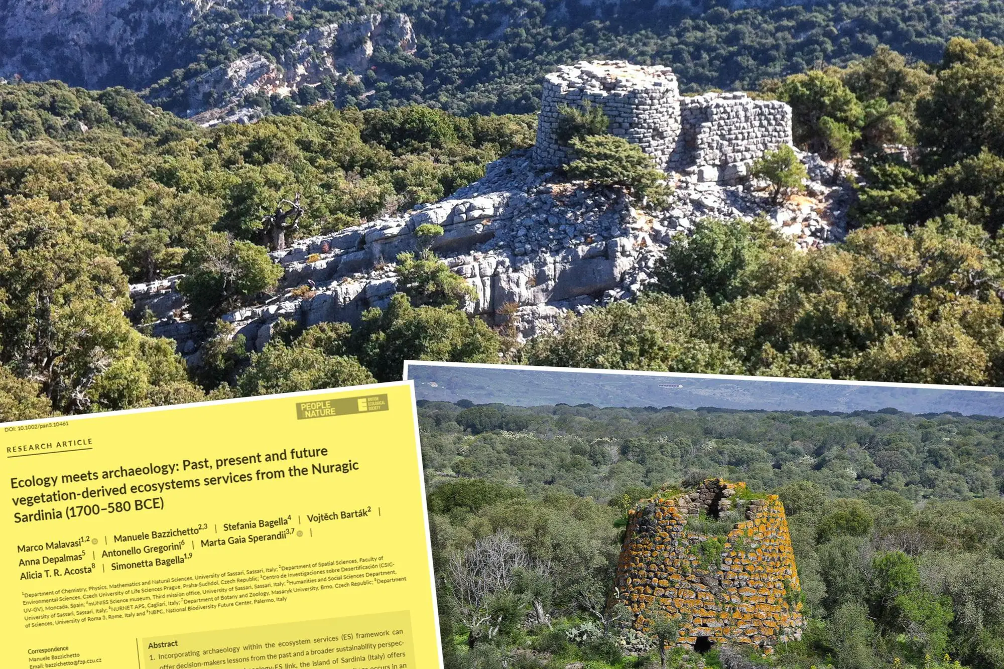
Per restare aggiornato entra nel nostro canale Whatsapp
They sighted the stars, they triangulated with the moon and the sun, they projected the sky onto the earth. Nothing was left to chance in the land of the Nuraghi. A civilization as ancient as it is mysterious, sculpted in landscapes transfused between gigantic monuments, strong and austere, and exclusive landscapes, painted by a nature marked by water and wind, uncontaminated and spectacular. To speak, four thousand years later, they are indelible signs of a profound and enlightened civilization like few others. A bottomless pit, where revelations and unpublished studies emerge every day, capable of shedding new light on the ancient history of the Sardinian people.
Gorropu tachycardia
Reaching the Supramonte di Orgosolo, emotional tachycardia stuff for those who are lucky enough, is a difficult undertaking, but not impossible. If you rely on expert guides, among paths and breathtaking landscapes, it will not be difficult to understand the unpublished conclusions of the study put on paper, and just published, by one of the largest global organizations of ecology and society, the British Ecological Society, the most ancient ecological society of the world. Projecting yourself onto those grazing hairpin bends, engraved by time around the Montes forest, means climbing up to the secret door to another world. The scents are tangible, they are so intense, the air is as rarefied as it is crystalline, the forest as ancient as it is luxuriant. If your heart holds up, look out into the deepest canyon in Europe, in that intrepid gorge that has always been called Su Gorropu here. The Flumineddu, the ancient stream that crosses the slopes of the Supramonte, has engraved it over the millennia as if it were a steel blade. Walls of white limestone, narrow and deep, which pierce the sea of pure green that surrounds them.
Nuraghe inside the wood
And then, on a spur perched like a lookout on the mountain, that primordial monument of the Nuragic people stands out, kissed by the sun and the moon, almost as if that limestone were a reflector. There, at an altitude of 835 metres, stands what mere mortals continue to call the Mereu nuraghe. In reality, handing down deep and ancient meanings, the locals continue to call it, as it should be, "Nuraghe intro 'e padente", "the nuraghe inside the woods". Impossible to glimpse if you remain lying on the forest path, sovereign and majestic once you get up there a stone's throw from heaven. A place imbued with rare beauty, where reconnecting with nature and the landscape is contemplation, meditation and listening. The toponyms of the landscape here are no coincidence: as nothing is. From Huvile Pistoccu to Huvile de S'Orada Hamposa, to Su Huvile Peleo to Su Huvile 'e Haapriles. The sheepfolds here, as in the atavistic millenary history of Sardinia, are set like that nuraghe, never by chance, studying its orientation and hinterland, agricultural and agro-pastoral potential, perceiving natural and environmental resources, with the perennial gaze turned to the primary good of water .
Ecology & archaeology
Never a case. It is here, as in thousands of other examples scattered across the most archaeological land in the Mediterranean, Nuragic Sardinia, that the intuition that becomes study, analysis, scientific and applied research emerges where «Ecology meets archaeology, between ecosystem services past, present and future derived from the vegetation of Nuragic Sardinia from 1700-580 BC» . In short, where and why did the Sardinians of four thousand years ago settle, why on that side, in that type of vegetation, with what economic and landscape objective, with what governance of the territory and the environment? An unprecedented cross-section with the superimposition of over 5000 nuraghes on at least 5 types of areas, with uniform characteristics distributed throughout the island. A map capable of reading backwards the "landscape" and urban-environmental choices of the ancient Sardinians, of interpreting their "governance" with man who became the regulator of a natural and economic balance of the territory. In short, a real architect of environmental, urban and economic planning of the territory, choosing the areas where to exploit the environment, taking root where natural and landscape resources allowed Sardinia to be modeled in the image and likeness of the ambitions of his own people.
British Ecological Society
The research, signed by Sardinian and foreign authors, has been on the home page of the most important ecological academy in the world, the British Ecological Society, certified by a global guru of environmental climate study such as Charles Watkins. The study is much more than a modern lesson in urban planning and land management. What emerges is a historical cross-section so innovative as to mark a new horizon for the analysis of the impressive identity, cultural and environmental legacy of the Nuragic civilization. The same scientists who signed the study say it: «Incorporating archeology in the framework of ecosystem services can offer decision makers lessons from the past and a broader perspective of sustainability» . In other words, to draw the future of Sardinia we should take an example from the history of its ancient people. A study made possible by the immensity of the unique archaeological heritage in an area of high biodiversity value, making the analysis of the places of Nuragic settlement superimposable with respect to the peculiarities of the variegated nature of the island. The study cross-referenced the map of the «Vegetation Series», the typologies of environment, nature and landscape, with the position of the nuraghes, allowing scholars to acquire a long-term perspective on the interactions between nuraghi and vegetation as a supplier of ecosystems. An analysis able to understand the past and the present, and potentially inform future practices for the territorial government of the region. In practice, the ancient Sardinians, from what emerges from the study, were able to interpret the "possible uses" of the environment and adapt them to the needs of growth and development. From the in-depth analysis, the dynamism of the environmental heritage emerges, almost shaped, to the point of making it an agro-forestry-pastoral landscape, as it is, in many ways, arrived today.
Soil and nuraghi
The results are decisive: «Ecosystems of plant origin represented a driving force in the land occupation strategies of the Nuragic people, who preferred, for their settlements, the mesophilic and secondary cork oaks, which, with cool climatic conditions on fertile substrates and gentle slopes on effusive igneous rocks, they provided land for grazing and agriculture». The osmosis that emerges from the analysis is a reciprocal exchange between man and the environment: «the Nuragic land occupation strategies have shaped the «Vegetation Series», transforming the landscape into agro-forestry-pastoral systems» . The researchers write: «Our results suggest that the origin of the current agro-forestry-pastoral landscapes in Sardinia could be traced back to the Nuragic civilization. The interaction between man and vegetation in Sardinia is ancient, reciprocal and dynamic».
Best practices
The picture that emerges from the study is that of a best practice from the past, full of meaning for the future: «These landscapes are a good example of intimate and sustainable relationships between people and nature and provide a strong sense of place and identity for the inhabitants of Sardinia». An interdisciplinary approach that "connects ecology with archeology, allowing for a better understanding of the environmental settings and the subsistence of the Nuragic civilization, a long-term perspective on human-vegetation interactions".
Vegetation series
It was the translation of archeology and the environment with a scientific method that established the correlation between the places chosen for the Nuragic settlement and the naturalistic characteristics of the territory. A painstaking work on over 5,000 nuraghes reported in the «Vegetation Series» areas by calculating the average number of nuraghes that fall within each vegetated area. The result is exemplary: the positioning of 75% of the nuraghi coincides with five very similar territorial-naturalistic typologies on an environmental level.
Nothing random
So, no coincidence. The ancient Sardinians mainly chose forest areas of «thermo-Meso-Mediterranean Sardinian holm oaks» and two different types of deciduous broad-leaved trees to position their nuraghes. Half of the nuraghes (2,352 nuraghes out of 5,453) were found in the two «Vegetation Series» belonging to the «Querco suberis» cork oak forest. Not a detail since already 4000 years ago the Sardinians, traces have been found, they used cork to isolate the nuraghes. The conclusion of the study is illuminating: 'Three main rural activities are practiced simultaneously in one space: the harvesting of forest products, livestock breeding and agriculture. In this context, the archeology-ecosystem connection can help to understand the origin of the current Sardinian landscape, suggesting that probably the Nuragics promoted the formation of these formations similar to savannas» . The study, signed by Marco Malavasi, Manuel Bazzichetto, Stefania Bagella, Vojtěch Barták, Anna Depalmas, Antonello Gregorini, Marta Gaia Sperandii, Alicia TR Acosta, Simonetta Bagell a, now travels the world. An extraordinary Nuragic lesson for the future, where man is the protagonist of his environment.
